
Exmoor National Park
With Exmoor National Park’s size, history, and geological variety, hikers are really spoilt for choice. We have highlighted a selection of the best walks in Exmoor that will help give you a flavour of what the park has to offer
A Selection of Popular Exmoor Walks
One of the most exciting and inspiring things a hiker can do is set out to a new region of the country, ready to take a deep-dive into some of the best walks the area has to offer.
Wherever an intrepid hiker ventures, there are opportunities for hiking – with careful planning and preparation, hiking can be enjoyed practically anywhere; but a few spots across the UK offer a bountiful selection of already well-trodden paths, which any keen hiker would do well to discover for themselves.
Some of the best places to make such an excursion are the nation’s many beautiful national parks, most of which contain a near-limitless variety of hikes to take and routes to explore.
With this in mind, today we’re heading South, and taking a look at 11 of the best walks in Exmoor National Park.
Introduction To Exmoor National Park
To those for whom hiking is a casual, occasional, or even rare activity, it can be easy to assume that the simple inclusion of the phrase ‘national park’ indicates a region will simply feature a lot of the ‘typical’ hiking fare. Long grass. Hills. Bogs. Big rocks.
But those with a keen eye come to appreciate that every national park plays host to its own rugged character – a history, topography, and geology all its own; a legacy carved from the very rock and earth upon which it stands.

Exmoor National Park is no exception and is truly one of the most inspiring locations in the United Kingdom to enjoy any variety of hikes. Named after the River Exe, which cuts its way through the centre of the park and spreads over an area of 692.8 km2 in West Somerset and North Devon. It encompasses several smaller regions, including the Brendon Hills, the East Lyn Valley, the Vale of Porlock and around 35 miles of the Bristol Channel coast.
A layer of sedimentary rock lies under the ground of the upland area of Exmoor National Park, which dates back to the Devonian era, and as hikers descend onto the lower slopes, they’ll be walking over stone as old as the Triassic and Jurassic periods. This is truly an ancient and historic landscape to visit.
The outstanding topography and geology of the park lend itself to an environment ideally suited to those who appreciate the great outdoors. Waterfalls, rolling hills, natural rock formations and ancient woodland abound, and the legacy humanity has left on the landscape can be seen in the form of standing stones, time-worn bridges, and even cairns. Whether your passion lies in nature or history, there is really something for everyone in Exmoor National Park.
Exmoor National Park – A Potted History
Interestingly, the park itself hides a rather regal history. While many national parks across the UK are charted purely for their landscapes or ecological value, Exmoor National Park is perhaps best identified as the location of the former royal hunting forest.
This area was originally also named Exmoor, contributing to the etymology of the current title, and was officially surveyed 1815–1818 as just shy of 19,000 acres! (Quite the back garden, it could be said…)
Granted a charter in the 13th century, the royal forest has played host to a variety of people and purposes; foresters who managed the area were identified in the Domesday Book, and in the Middle Ages sheep farming was common, with sections of Exmoor divided up as the Inclosure Acts carved up ownership of the landscape across the UK. It became Britain’s eighth national park in 1954.
One element of Exmoor’s history which sets it apart somewhat from other national parks in the UK is the prevalence of historic buildings and settlements; along with the aforementioned standing stones and cairns, a wide variety of small villages, farms and hamlets contribute perhaps more than anything else to the region’s character and personality.
All of these features blend together to create a hiking landscape which is rich, diverse and guaranteed to contribute a memorable and unique ‘notch’ in any hiker’s belt.
The Best Walks In Exmoor National Park
With Exmoor’s size, history, and geological variety, hikers are really spoilt for choice when it comes to routes and walks to experience. Whatever your level of experience, there’s something here for you – from short walks with a well-earned pub lunch at the end, to in-depth, challenging hikes that even the most seasoned hiker will find rewarding.
We’ve collected a few of our favourite walks here, collated from a combination of personal experience, recommendations, and detailed research. We’ve also included a quick-reference guide for each hike, detailing length, difficulty, estimated time to completion, and even where exactly to park and start walking – while this is by no means a comprehensive list, we really feel that these are 11 of the best walks in Exmoor National Park.
We should note that while we include a summary of what you can find on each of the walks, and what makes them special, here, we don’t include a detailed breakdown of the route (that would take up an entire guidebook’s worth of writing!)
Instead, this guide is intended as a source of inspiration and a starting point for your own research. If you like the sound of any of these walks, more detailed guides and route maps can easily be found online.
Covid19 Hikers’ Tips
With the pandemic changing the way we approach many day to day activities, hiking is no exception, and it’s important to note a few things to ensure you can enjoy your hike safely while protecting yourself and any other walkers you may encounter:
- Maintain social distancing (2 metres)
Even though hiking is an outdoor activity, it’s important to keep to social distancing guidelines – remain 2 metres apart from any other hikers you may encounter. This is particularly relevant for some of the hikes we’re looking at that include sections when you’ll be walking through villages and hamlets.
- Wait until it’s clear to walk through narrow areas of limited access
As you’re hiking, you may come across some slightly narrow areas, such as bridges or steeper paths. If this is the case, and there are several people waiting to cross the area, it’s a good idea to wait until it’s completely clear before moving on, to avoid coming into unnecessarily close contact with one another.
- Look out for any new signage
Some routes and trails may feature new signage which has been installed to provide up-to-date Covid guidance. Pay attention to these, and be mindful to follow any applicable guidance they may offer.
- Carry hand sanitiser and regularly sanitise hands
Bring a fresh bottle of hand sanitiser with you on any walks – if your hike takes you through any gates, or over any stiles etc, make sure to sanitise your hands both before and after touching anything, and try to avoid touching your face during your hike if you can!
1. The Valley of the Rocks Walk
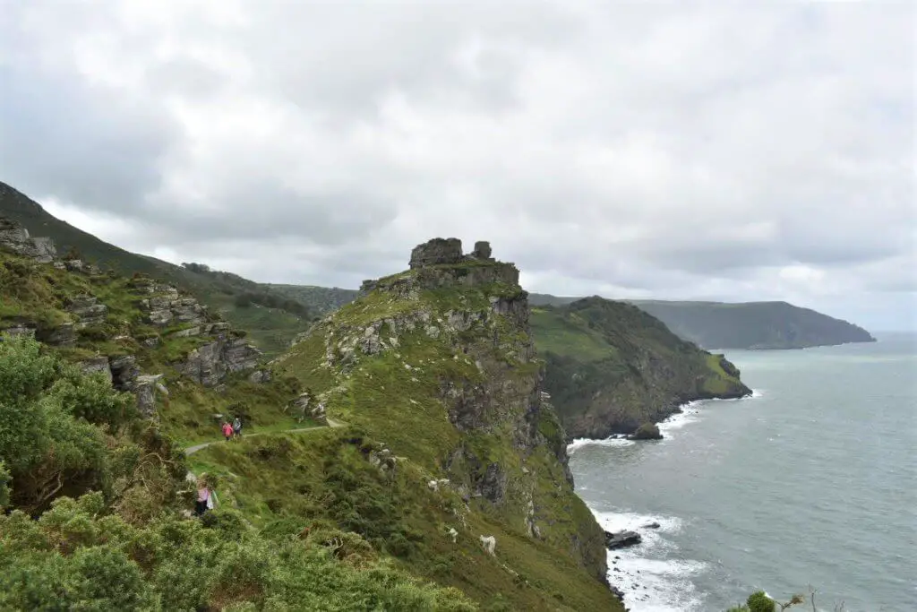
First in our list is one that we took the time to experience firsthand, and we can safely say we’re very glad we did. The Valley of Rocks walk is a fantastic way to experience some of the very best that Exmoor has to offer when it comes to views – a combination of breathtaking geological magnificence, and sublime coastal grandeur. This is an enigmatic, captivating part of Exmoor National Park, and its proximity to the small town of Lynmouth makes it an ideal circular walk for keen sightseers to young families (who may well have earned an ice cream or even a cream tea by the time the walk comes to a close…)
Key info:
Walk distance: 4.99km
Difficulty: Fairly easy
Time: 2 – 2.5 hours
Map: OS Explorer OL9
Starting Grid reference: SS 722 496
Parking: Several options – we chose the Esplanade Car Park, EX35 6EQ
Summary:
This one is a real treat for those who enjoy spectacular natural views, particular those of a coastal or geological nature. Some of the rock formations on this walk will stay in our memory forever, they’re just so astonishing – and there’s little doubt in our mind that this is one of the best walks in Exmoor National Park.
The walk itself starts with a bit of a climb – the path zigzags, which makes it a little more bearable, but those with small children or anyone looking for an easier hike can always opt to take the historic Lynton and Lynmouth Cliff Railway!
With the initial ascent out of the way, the rest of the walk features some truly breathtaking coastal views – along with some inspiring local culture; one of the early sections of the route takes you to the ‘Poems Walk Coastal Route’, which features some lovely poetry inspired by the incredible landscape.
Sights along the way include Castle Rock – a magnificent turret-like rock formation – and even a herd of goats, introduced to the area from Northumberland in 1976.
All in all this route is a perfect introduction to Exmoor and can be enjoyed all year round, although it can be noted that this particular stretch of coast takes on a fantastic character in the Autumn when the gorse and heather emerges and turns the landscape into an oil painting.
Read about our experience of the Valley of the Rocks Walk.
2. Watersmeet Walk
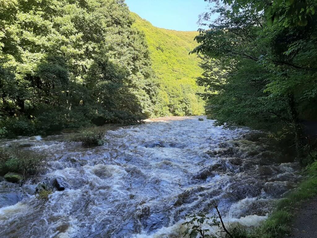
If you find yourself in the picturesque north Devon town of Lynmouth then the Watersmeet walk is an absolute must. Stroll alongside the spirited East Lyn river as it winds its way through the steep, tree-clad gorge. Stop for a well-earned break in the idyllic tea garden of Watersmeet House which sits at the confluence of the East Lyn River and Hoar Oak Water. Then return to Lynmouth via the Woodland walk that offers some wonderful views up the river valley.
Key info:
Walk distance: 3.96 miles
Difficulty: Easy
Time: 2-2.5 hours
Map: OS Explorer OL9 (not really required)
Starting Grid reference: SS 724 494
Parking: Two car parks available near the start – Upper and Lower Lyndale car parks
Summary:
With a starting point just a short distance from the town centre, the Watersmeet walk is super convenient and well worth the effort. Whether you grab a parking spot in either of the Lyndale car parks or somewhere else in Lynmouth, you will never be far from the start.
The walk commences on the bank of the East Lyn River and you never venture too far from the river as you make your way upstream on the outbound section. In fact, there are parts of the walk where the trail narrows and literally hugs the river’s edge, meaning a little caution is advised.
Keep your eyes peeled at all times as the river valley is a veritable wildlife haven boasting herons, dippers and grey wagtails as well as otter and red deer. During winter you may well spot salmon leaping upstream to spawn!
When you reach the National Trust’s Watersmeet House you are halfway through the walk and what a location to take a break. In fact, I will go as far as to say that you will struggle to find a more beautiful tea garden in the UK, so grab that cream tea and soak up the atmosphere before continuing on your way.
The return portion of the walk takes you on a slightly different trail, this time leading you further up the valley side affording you some super views of the river below.
Read about our own experience of the Watersmeet Walk.
3. Dunkery Beacon Walk
![]()
Dunkery Beacon itself is the highest point in Exmoor, and it’s a fantastic vantage point from which to enjoy stunning and uninterrupted views of the breathtaking surrounding landscape. Despite the altitude, thankfully, the Dunkery Beacon Walk itself isn’t too challenging – meaning the vast majority of hikers will be able to make the most of the experience!
Key info:
Walk distance: 1 mile
Difficulty: Very Easy
Time: Up to 1 hour
Map: OS Explorer OL9 (not really required)
Starting Grid reference: SS 8954 060
Parking: Two car parks available on the road – well signposted off the A39 (TA24 7AT)
Summary:
The Dunkery Beacon walk is a pleasant, easy walk which is a lovely way for even the youngest hikers to enjoy a walk to one of the most fantastic natural landmarks on Exmoor. It may only be short, but this is, without doubt, one of the best walks in Exmoor National Park, and definitely worth a visit – it’s so brief, you can easily weave it into any number of other walks, or even a weekend break in the local area.
After parking at one of the two small car parks, it’s very easy to head straight for the Beacon itself. The walk is short, and merciful but generous in its reward. Dunkery Beacon stands at 520 metres above sea level, and if you’re lucky enough to visit on a clear (or even sunny) day, the views are something to behold.
From the summit, you’ll be able to cast your eyes not only over much of Exmoor but as far as Dartmoor and even the Brecon Beacons in Wales. The eyeline stretches to both Severn Bridges, and the all-encompassing horizon is a really poignant reminder of just how fortunate UK hikers are, in that they get to experience so many wonderful landscapes such as this, in such proximity.
Find out more about our own experience of the Dunkery Beacon walk.
4. Dunster Circular

Dunster is one of the many historic villages that dot the landscape of Exmoor, and along with its own structures and character, it lies in proximity to some well-preserved Roman settlements – some of several that the Romans built along this stretch of coast to keep an eye on what they thought was an impending invasion from the Silures in Wales (they never invaded…)
Key info:
Walk distance: 4.3 miles
Difficulty: Medium
Time: 2 hours
Map: OS Explorer OL9
Starting Grid reference: SS 993 438
Parking: Dunster Steep Car Park
Summary:
The Dunster Circular is a delightful walk, which is only more challenging than many of the easier walks on this list due to its length. The route takes you through the village itself, past a working water mill, across a stream bridge, and offers great views of the River Avill Valley.
Aso along the circular route is Bats Castle, one of the Roman Settlements, and Gallox Bridge – a longstanding stone bridge which is a lovely place to play pooh sticks!
This route is very much more of a walk than it is a hike, but for those seeking out a little more of the manmade history and culture of Exmoor, Dunster is the perfect spot to enjoy an afternoon’s walking.
Check out the Dunster Circular route guide
5. Larkbarrow Archaeology Walk
Larkbarrow is the first of several ‘archaeology’ walks we’ll be taking a look at; they’re a delightful series of routes dedicated to showcasing some of Exmoor National Park’s rugged archaeological history.
Larkbarrow takes hikers past several ruined farms, all of which carry with them their own unique stories and historical value, and the walk itself is a pleasingly challenging moor hike for those looking to break in their walking boots.
Key info:
Walk distance: 4 miles
Difficulty: Quite challenging
Time: variable, but at least 2-3 hours
Map: OS Explorer OL9
Starting Grid reference: SS 8275 4175
Parking: Lay by at the grid reference above
Summary:
We should preface this one by saying that whereas some of the walks on this list will take you through guided paths and signposted routes, some of the archaeological walks on Exmoor require hikers to cross open moorland, and for this reason shouldn’t be attempted without a map, compass, good hiking equipment, and plenty of preparation.
It’s also a really good idea to bring some kind of guide with you (not as in a native who knows the area, but a simple field guidebook or even a printout of the route guide), not least because without some inside knowledge, you might pass something by without knowing its significance! There are a few good sources – we’ve found this route layout to be really helpful.
With that said, the Larkbarrow walk is a fantastic challenge for those looking to get out onto the open moors, where nature has reclaimed much of the landscape that mankind once tried to tame. The site of Larkbarrow Farm was home to an excavation in 2008, which uncovered over 500 pieces of flint, and other examples of Mesolithic life in the area!
Check out the Larkbarrow Archaeology Walk route guide
6. Exford Circular Walk
Another pleasant village walk, this time passing through Exford. This circular route offers a rolling walk with several height changes, and an enjoyable path along the river Exe, and even a dip into a hidden valley…
Key info:
Walk distance: 3.8 miles
Difficulty: easy to moderate
Time: 2.5 hours
Map: OS Explorer OL9
Starting Grid reference: SS 853 384
Parking: Car park opposite the Crown Hotel
Summary:
This is a really lovely route, taking visitors through the delightful village of Exford, and along the River Exe. Close to the village are the prehistoric enclosures of Road Castle and Staddon Hill Camp and an Iron Age hill fort – Cow Castle – lies to the west.
There isn’t an awful lot we can say about this walk, other than Exford is a really brilliant place to visit if you’re looking to experience an ‘authentic’ taste of Exmoor; along with the river itself, the village is a picturesque slice of this untouched part of the world, with its own potted history making it worth a visit: the bridge over the river was built on a medieval site in 1930, and the Devon and Somerset Staghounds have had their kennels – originally built by Montague Bissett, at the village since 1875!
Check out the Exford Circular route guide
7. Lynton Circular
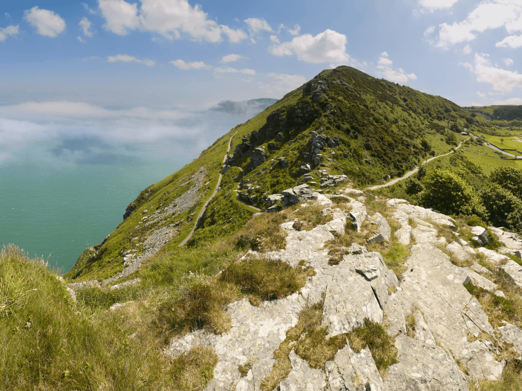
This circular route through the town of Lynton offers visitors to the park a real melting pot of experiences. If you’re looking to take in as much of Exmoor as you can in a relatively short period of time, this is a really fantastic option – Lynton and Lynmouth are known as the ‘walking capitals of Exmoor National Park’ for good reason!
Key info:
Walk distance: 6 miles
Difficulty: moderate to challenging – purely because of the climbs!
Time: 3 hours
Map: OS Explorer OL9
Starting Grid reference: SS 720 494
Parking: Car parks in Lynton – walk starts at the high street.
Summary:
This is a slightly longer walk, but it’s a really fantastic option for a flavour of all the best the area has to offer visitors. The route itself winds around several sights that crop up on other dedicated walks on this list, including the Valley of Rocks, a section of the coastline, and some inviting woodland.
If you’ve only got the time to try one walk on your stay, and you’re considering Lynton as your base of operations, we’d probably recommend this one. You’ll head past the Cliff Railway and can enjoy some really lovely views over Lee Bay.
There are some more sombre sights – you’ll pass the flood disaster cemetery, which honours those lost in 1952 in a terrible flood in the area – but the views from Hollerday Hill are a good way to reflect and pay respect to nature, the power of which this location is a staunch reminder of.
The addition of more than one picnic spot along the route make this walk approachable with younger hikers, although you’ll need a competent level of fitness to attempt this one due to some rather sharp climbs along its route. That’s nothing a thermos of tea and some ham sandwiches can’t help you recover from…
Check out the Lynton Circular route guide
8. Selworthy Beacon & North Hill from Bossington
![]()
So far, the walks on this list have been slightly shorter, more approachable walks, but we know there are plenty of hikers out there who will want a slightly more indulgent experience when it comes to walking on Exmoor National Park.
This Selworthy Beacon and North Hill route is quite a bit longer, at 8.5 miles, and will take the better part of a day to complete. Perfect for those looking for a full day’s walking, and who want to enjoy all that Exmoor has to offer without feeling like they’ve had to compromise.
Key info:
Walk distance: 8.5 miles
Difficulty: Moderate
Time: 5.5 hours
Map: OS Explorer OL9
Starting Grid reference: SS 898 479
Parking: TA24 8HQ, National Trust car park
Summary:
The walk starts in Bossington (and it’s worth noting that the village itself is worth a wander around either before or after the walk, ensuring a full day’s excursion for those who want it). After a steep climb, a short detour can provide you with incredible views over the whole or Porlock Bay.
From Selworthy Beacon, you can see all the way to Dunkery Beacon, and right over the higher moors of the national park. Other highlights along the route include the whitewashed Selworthy Church, and views over the thatched roofs of cottages that were constructed for the retired workers on the local Holnicote Estate.
Selworthy itself is a lovely and attractive village, and the route continues on through Allerford, which features a famous packhorse bridge. All in all, a lovely way to experience a variety of delights that this part of Exmoor has to offer.
Check out the Selworthy Beacon & North Hill from Bossington route guide
9. Minehead Circular

A walk with a slightly different flavour, as you can arrive by steam train! This circular walking route in Minehead is a fantastic combination of rural country living and natural woodland features – some of the moss and lichen in this area is really amazing.
You’ll also be able to take in some incredible views across the Bristol channel, and while this is a slightly longer walk, clocking in at around 3.5 hours, it’s manageable for most, with the majority of the route offering easy walking.
Key info:
Walk distance: 5.9 miles
Difficulty: easy to moderate
Time: 3.5 hours
Map: OS Explorer OL9
Starting Grid reference: SS 974 463
Parking: West Somerset Railway Station
Summary:
This one starts with a long, progressive climb, followed by a short although steep descent – once you’ve cleared this section though, it’s plain sailing, so this route will suit hikers with a wide range of abilities and fitness levels.
Starting from the West Somerset Railway, the route follows the old South West Coastal Path – this provides the gentle climb which leads to North Hill, and once you emerge from the woodland the views are really spectacular.
The route is also very well designed to ensure not too much road walking – while you’ll pass through the hamlet of Bratton, and Minehead itself, for much of this you’ll be walking on delightfully separated paths; allowing you to experience the beauty of the area and local settlements while not having to risk walking in traffic.
Minehead itself is a beautiful example of Somerset culture. It’s known, famously, as a gateway to Exmoor, and with its own beaches, fishing district, harbour, and even a 14th Century church, there’s plenty to explore here for a memorable walk and a fantastic day out.
Check out the Minehead Circular route guide
10. Badgworthy Archaeology Walk
Another archaeology walk, and this one also takes you right out into the heart of the moorland. The Badgworthy archaeology walk is slightly less challenging than Larkbarrow, but it will also require the use of the OL9 map and plenty of preparation.
Key info:
Walk distance: 6 miles
Difficulty: Moderate
Time: Varies – expect 3-4 hours
Map: OS Explorer OL9
Starting Grid reference: SS 7651 4325
Parking: Parking beside the road at Brendon Two Gates on B3223 from Simonsbath to Lynmouth.
Summary:
As with any open moor walking, this one is best not attempted in bad weather – particularly fog. Providing you’re well-prepared, and bring your OS Explorer OL9, you should be okay – and the experience of hiking this part of the moor really does ensure this is one of the best walks in Exmoor National Park.
Many people visit Exmoor to experience its archaeological history, and this is a great walk if that’s your plan. You’ll pass the boundaries of the historic former Royal Forest of Exmoor, and come across standing stones, ruined buildings, and even a deserted medieval village.
In this village, 14 medieval buildings survive as low stony banks, rectangular in shape – well worth a visit, and a photo opportunity. If you’re an avid reader, you could also prepare for the Badgworthy archaeological walk route with a copy of R.D Blackmoore’s novel, Lorna Doone, which famously fictionalises this location as ‘Doone Village’.
Check out the Badgworthy Archaeology Walk route guide
11. Tarr Steps from Dulverton
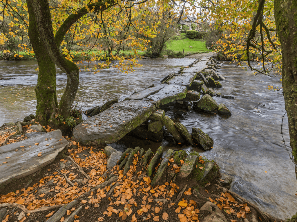
The last walk we’ll be featuring is one of the most well-known routes on the moor and is certainly one of the best walks in Exmoor National Park. Tarr Steps itself is a clapper bridge (a bridge made of unmortared natural stones), and is a well-known tourist attraction in its own right.
For those of us who prefer the journey to the destination, however, there is a lovely hike to be had – the River Barle, and its wooded valley, is a real delight, and there is plenty of phenomenal flora and fauna to be discovered on this walk – including the wild ponies of Winsford Hill!
Key info:
Walk distance: 12 miles
Difficulty: Moderate
Time: 6 hours
Map: OS Explorer OL9
Starting Grid reference: SS 913 279
Parking: TA22 9EX – Walk starts at the National Park Centre in Dulverton
Summary:
This is, surprisingly, the longest walk in this guide – clocking in at around 6 hours and spanning a total of a whopping 12 miles. With that said, the route has plenty on it to keep you interested and includes some of the best ‘must-see’ sites that Exmoor National Park has to offer.
Tarr Steps itself is an ancient bridge, first mentioned in the Tudor period, but it’s likely a lot older than that. The bridge often requires repair, as during times of flooding, the now-silted river rises up over the stones themselves – this isn’t a walk to attempt during periods of heavy rain!
The route also takes you through the woodland around Tarr Steps, which was made a National Nature reserve in 2004. The mosses, liverworts, and lichens here are of international significance – including one type of burrow moss which appears to glow in the dark!
Otters, dormice, eels, and other amphibians all call this location home, and this particular route also takes you to Winford Hill, which is home to the Anchor herd of Exmoor ponies.
The pure-bred ponies have an anchor brand mark – the symbol of the Acland family who once preserved the breed in the former Royal Forest of Exmoor. They roam free, and it’s thought that they are in fact not even a breed of wild horse – rather, they’re an entire race.
Check out the Tarr Steps from Dulverton route guide
Best Walks in Exmoor National Park – Final Thoughts
Exmoor is a really special place and offers hikers a unique flavour of nature in Britain. With its many towns and settlements, its walking routes differ to those of places like the Brecon Beacons National Park – these hikes are less about conquering rugged open moorland, and more about absorbing yourself in history both manmade and natural.
The coastal views, the incredible geology, and the immersive living history of this part of the UK make Exmoor National Park a must-visit for anyone with a passion for hiking. While the walks we’ve collected here offer a fantastic starting point, there is so much to be discovered here, we may well be writing another guide in the future…
If you have any questions or would like to share your own experiences of Exmoor, we’d love to hear from you! Feel free to leave a comment below, and we’ll get back to you shortly.
Discover some of the best walks in other UK National Parks
- Brecon Beacons National Park
- Dartmoor National Park
- New Forest National Park
- Peak District National Park
- Snowdonia National Park
Like Our Article? Please Pin it!


Leave a Reply